Freeway Free in Delaware: Along the Eastern Shore


I’m a West Coast person, so a visit to the eastern shore of Delaware feels as exotic as a trip to the Caspian Sea. In California we don’t go to the shore at all, we go to the beach. Usually a particular beach, defined by the sandstone cliffs that surround it on three sides. You can see from one end to the other of the beach, and usually walk it in less than a half hour. But on the East Coast, you go to the shore, and the shore is LONG. It stretches as far as you can see in either direction. You can go a couple of miles along a boardwalk, and when the boardwalk ends, the shore still goes on and on.
Scattered along the endless shore are beach towns, Rehoboth Beach, Dewey Beach, Bethany Beach, and across the border in Maryland, Ocean City. If you are a local, you know that each town has its own personality, and caters to a particular kind of visitor. There is the family beach town, the gay beach town, the college-kids-on-Spring-Break beach town, the beach town for retirees. To an outsider, it’s all one stretch of shore with intermittent boardwalks and stores selling kitschy items and salt water taffy and frozen custard. (Frozen custard? Think ice cream made with eggs. It’s an East Coast thing. But don’t look for shave ice – that seems to be a West Coast thing.)
If you continue south past Ocean City, you will find yourself in Assateague State Park, headed for the Assateague National Seashore. If you ever read Marguerite Henry’s MIsty of Chincoteague as a child, you know the tale of how a small herd of horses survived the wreck of the Spanish ship off the coast of the barrier islands of Maryland, and how their feral descendants still survive on these inhospitable sandy spits of land.
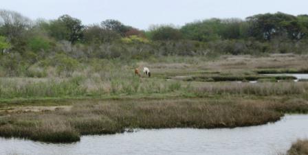 I had read the story, and was eager to see the ponies. Unfortunately, on this day the ponies were as elusive as moose in Maine from a tourist bus. We saw some deer, and some water birds, but nothing equine. Finally, as we were ready to turn back, we spotted a pair in the far distance on the other side of an inlet. (Thank goodness for telephoto lenses) One was chestnut, the other was the classic pinto as in Misty. Hooray! If I’d had a bucket list, I could have checked these off.


On the way out of the park, we spotted another pair of ponies, but all the parking space on the roadside was already filled with other visitors who had pulled over for a picture, so we did not stop. One check mark was enough.


 We had planned to leave at 7AM for
  With a sigh of relief, I spot a privy decorated with a cowboy mural down a little side road. The Visitors’ Center is 17 miles further on. The gravel road is bordered with ocotillo (long slender bare dead-looking sticks with flames of bright red flowers blooming at the tips) and Spanish bayonet (giant pompons of green narrow leaves cupping a torch of white and pinkish downward-facing blooms) and lots of bare earth where the cattle have grazed and platinum blonde grasses where they have not.

 After about an hour of jouncing over mostly-pretty-good gravel road, we get to the Visitor’s Center, a plain building with a minimal gift shop and a sign saying “Welcome to the Other Side of Nowhere.” The center also offers an up-to-date set of rest rooms with cool running water, and a friendly ranger who supplies us with trails and suggestions. We decide to eat our lunch at the lone picnic table under the lone bit of shade, and then head out on the Horse-Trap Trail that promises a view out over the central interior of the park, and possible encounters with local wildlife.


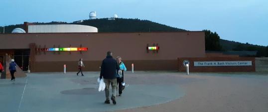 W had made arrangements for us to attend a Star Party at the McDonald’s Observatory 15 miles west of the Lodge. We knew reservations were required and had them, but did not realize that each party had over 200 invitees. I negotiated the twisty road in Moby Dick, our outsized 4×4 pickup, and parked in daylight, hoping to be able to find the truck later in the dark.
 We were early for the star-gazing, and browsed the Visitors’ Center and Gift Shop, as my spouse, a big fan of the Observatory’s Star Date broadcasts on PBS, had asked me to bring him something from MacDonalds. I managed to find some postcards and an affordable and portable book at the gift shop, and made it through the line at the cash register just as they were calling for the partygoers to come to the outside auditorium for the start of the star gazing.
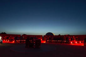 Whatever did we do before fleece! Cozy in fleece jacket and pants and three layers beneath, topped with hats and scarves, we sat on concrete benches as the star ranger pointed out details we had never seen before of Orion. The ranger drew a big laugh with his description of “the hunter, he has a sword, shield and these two bright stars mark his brawny shoulders, but like some other athletes, his head is this fuzzy thing…;” We were introduced to Leo, Taurus,
 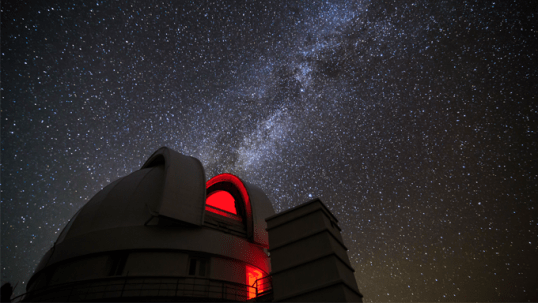 Then the host recommended we adjourn to the telescopes for viewing, as clouds were beginning to obscure the sky. There were three outdoor telescopes and two domes open, but even though some of the 200+ viewers had left the amphitheater early to get a head start, there were still long cold lines. We wished we had a fourth fleecy layer. We saw the Pleiades up close and two star clusters and then headed for the interior Sky Tour, which was rather redundant but at least it was indoors, warmish, and sitting. We bailed at 10:30, foregoing another classroom talk, and I drove prudently down the mountain. We crashed into bed at 11:15, piling on all the warm quilts we could find.
 Ft. Davis National Historic Site


 If you stop, I can recommend the


 If you are going to spend time in the desert, it’s best to know what you may be seeing, smelling, and getting stuck onto. The Chihuahua Desert Research Institute and Botanical Gardens, about 10 miles east of Ft. Davis, provide a convenient and comprehensive introduction.


 A trail leads off from the parking lot, so we put on boots, grab sticks, and off we go, altitude, loose rocks, and elevation gain be hanged! We make it about half a mile up the trail before stopping to look at the Lodge below and deciding we had done enough.


 We weren’t very far off of Interstate 10, the scarlet ribbon on our map which bisects West Texas between San Antonio and El Paso, when we pulled off at
 The oasis is now civilized, thanks to the efforts and energies of the Civilian Conservation Corp in the 1930’s. The swimming pool fed by the spring is now enjoyed by families and scuba drivers (in the deep part). No thirsty mules or cattle are allowed to approach. There are changing rooms, picnic tables, and a snack bar. But the presence of abundant water in the midst of the sagebrush is still miraculous.
 OK, I’m cheating a little. We actually spent quite a bit of time on the freeway on our way to the Big Bend area of west Texas – there is no other way to get there.
 So off we go out of Austin and past places that we have visited before, into the unknown spaces of the Big Bend country of southwest Texas. We move out of the area where bluebonnets and scarlet paintbrush are blooming and into an area where odd geological formations punctuate the skyline like very broad pencils with sharp tips. Scattered yuccas bloom like pale torches among the scrubby bushes. The occasional farm augments its income with pumpjacks in the valleys and windmills on the ridges, hedging its bets between the old energy and the new.
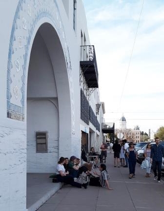
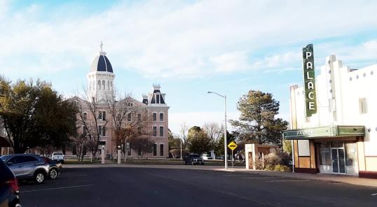 Marfa, in the Big Bend Country of Texas, is the home of the mysterious
  But the real mystery of Marfa is not the lights, but how a town of scarcely 3000 manages to maintain not just the grand old